Urban Planning Services
Whether planning for small areas, neighborhoods, or entire cities, the best plans bring diverse stakeholders together, in collaboration, to meet today's needs and envision the future. Balancing critical thinking, analytical tools, and technology with sound economic and community planning principles, Civicus creates focused plans that are meant to be implemented.
Our urban planning services include:
- Land Use Planning & Mapping
- Neighborhood Planning & Studies
- Comprehensive Planning
- Strategic Planning
- Community Development
- Housing Studies
Urban Planning Projects
Haughville Neighborhood Study
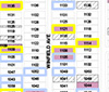
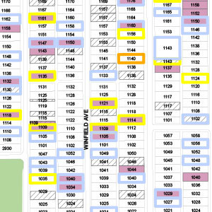
The Haughville Neighborhood Study catalogued vacant land, tax delinquent properties, foreclosed properties and distressed housing. Four levels of distressed housing were identified and coded based on a combination of housing repair orders, housing boarding orders, tax sale property and long-term utility disconnections.
Contact civicus today about conducting a neighborhood or land use study.
[ Download the Haughville Study Map ]
Midtown Neighborhood Study
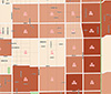
The Midtown Neighborhood Study catalogued vacant land, unsold tax sale parcels and distressed housing. Four levels of distressed housing were identified and coded based on a combination of housing repair orders, housing boarding orders, tax sale property and long-term utility disconnections. Additionally, maps were created to highlight Neighborhood Health Indicators and detailed population gain/loss. Proposed TIF district boundaries and eligible Neighborhood Stabilization Program (NSP) Census block groups were displayed for reference.
[ Download the Midtown Neighborhood Maps ]
Lawrence, Indiana Housing Study Map
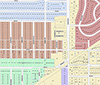
The Lawrence, Indiana Housing Study Map was created for the Lawrence Community Development Corporation from a digitized, hand-drawn map. The map created five distinct housing study areas based on actual parcels.
[ Download the Housing Study Map ]